Existing Solar Models
Šúri, et al., (2008) performed an elaborate overview on classifying map-based spatially-distributed solar radiation databases with reference to the following criteria; input data, period of time, spatial resolution, time resolution, methodical approach and simulation models. Each solar model has been critically evaluated in terms of benefits and limitations with an overall summary shown in Table 1.
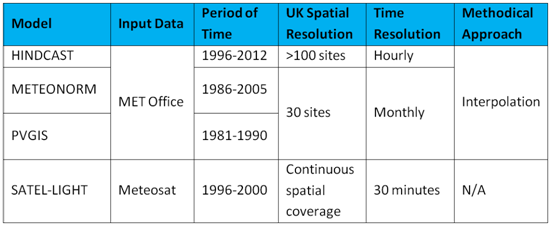
Table 1: Solar Model Comparison
Meteonorm
Meteonorm is widely used for PV simulation. The in-built database contains solar radiation measurements collected from a combination of several databases. According to Cros, et al., (2004) and Šúri, et al., (2008), it uses observations from (GEBA, WMO/OMM, MeteoSwiss, etc). Through examination of the station map (Meteonorm, 2012) it is clear that a limitation of Meteonorm is that only 30 MET stations have been integrated into the model.
Based on reviews of Kaplanis (2005) and McCracken (2011), Meteonorm uses high resolution data in terms of time (1 minute time steps) but on reviewing each of these journals it becomes clear that the high resolution data is infact derived from monthly data. This defines time resolution as a limitation. Furthermore the time coverage has been identified as another limitation due to the data measurements taken from 1986 to 2005, as explained in McCracken (2011).
An interpolation technique has been used to derive data at any point in the UK. In terms of “simulation models” Meteonorm (2012) states that it can derive global irradiance for inclined surfaces. On the other hand the solar hindcast model cannot but it does have the ability to derive a synthetic time series.
Overall Meteonorm is a good tool for PV simulation but with the limitations of monthly data and the number of MET stations this model would not provide the appropriate results required from a hindcast model to understand the variability of solar radiation.
Photovoltaic Geographical Information System (PVGIS)
PVGIS is used for geographical assessment of the solar energy resource. The PVGIS database source is MET stations that are situated across the UK with a monthly averaged time resolution (Šúri, et al., 2008). It uses a data measurement time period from 1981-1990 according to European Commission (2005) and Šúri, et al. (2008). At this point it has been identified that the spatial resolution, time resolution and time period are all limitations of the PVGIS model.
The final factors of consideration are methodical approach and simulation models. According to Šúri, et al., (2008) and European Commission (2005), PVGIS uses an interpolation technique between each of the MET stations and includes a calculation to estimate solar radiation on inclined surfaces.
In summary this model would not provide the accuracy of results required to understand the variability of solar resource this is attributable to the limitations in the time resolution and number of MET stations.
Satel-Light
Satel-light is a European database of daylight and solar radiation. According to Cano, et al., (1986), half-hourly global irradiance is derived data from hourly satellite images (Cros, et al., 2004) taken by the geostationary satellite known as Meteosat. Based on a comparison performed by Šúri, et al., (2008), it has been indicated that satellite databases show generally higher values compared to the databases relying on ground observations. This is partly due to “satellite-derived databases being affected by higher uncertainty of the cloud cover assessment when the ground is covered by snow and ice and for low sun angles”.
The data measurement time period that Satel-light uses is between 1996 and 2000 (Šúri, et al., 2008) (Cros, et al., 2004). This defines a limitation of Satel-light due to the short time duration in comparison to the other models. A benefit of Satel-light is that the data from Meteosat has continuous spatial coverage and hence an interpolation technique was not required to be integrated to estimate the global solar radiation at a random point in the UK.
Overall Satel-light does show the capability to be used to understand the variability of solar resource but with the values being slightly higher there is an area for improvement. In addition with a short time period (1996-2000) Satel-light will not provide the same precision as the hindcast model (1996-2012) when determining solar variability.
Graham Cairns
University of Edinburgh, 2013
University of Edinburgh, 2013
